
Gaining Momentum: E. Glacier to Benchmark
Day 11: It's always hard to get out of town early. I had Wi-Fi chores left to do. Eventually we trudged over to the lodge and up through the lot, expecting to see little bear again; instead we ran into a whole mess of golfers. We walked past the first tee, crossed a bridge to an old road, took a right past the dilapidated shack and followed a jeep road to skirt private property - all as the notes on our map dictated.
Just before we re-entered Glacier, I saw a brown shape at the edge of the trail up ahead. It clambered over some brush and lit out down the trail.
"Oh, it's a bear," I said, surprised by my own nonchalance. It was a small grizzly, maybe two years old, but large enough that I wasn't worried about its mother being around. Finally! I was the only one in the group that had not yet seen a bear this trip.

I couldn't bust the camera out quickly enough, so here's that griz from the first day again.
The sixteen miles to Marias Pass were beautiful, but compared to the last hundred plus miles, ho hum. We got few if any views past the trees and much of the scenery was redundant. The "pass" is a major highway. There's a big obelisk monument designated to Teddy Roosevelt, a campground, the Summit Lodge and a railroad.
From here we had three route choices. One was cross-country (i.e there's no trail) and one involved a road walk; we took the third choice. This route took us through a massive burn with literally hundreds of blowdowns. For over four miles we had to climb over, walk around, duck beneath or balance across literally hundreds of downed trees. It was fun at first, actually, rather like a jungle gym, but my legs were getting ripped up by branches and I smashed my shins against solid logs a few times.

New life in the burn scar
We broke for dinner at a creek and decided we'd camp as soon as we found flat ground that wasn't beneath dead standing trees. This only took a little while, landing us at 21 miles on the day. Back on track.
Day 12: I generally don’t listen to music or podcasts when I hike (especially in grizzly country), but I keep both on my phone for days where morale or motivation are lacking. This day both were in full supply, but one of my favorite bands had just released a new LP, so I popped the ear buds in straight out of camp.
The rest of the morning and early afternoon were, well, uneventful. Eventually we came to the Badger Patrol Cabin: a Forest Service cabin with water pump and horse corral. From here we had two route options, hardly different in mileage or topography, so we went with the route drawn in red ink, which is generally the way Jonathan Ley (the route plotter/cartographer) suggests.

Lots of flat jeep road walking through the afternoon, complete with huge grizzly tracks in the mud. In the evening, we came upon a creek and ran into Chewy, another southbounder whom we had met in East Glacier. He was having knee problems and had only hiked a few miles that day, but assured us he was fine. We ate dinner with him and trudged off with bloated bellies toward Lost Horse Camp, something like twenty miles on the day.

Next to my Mens' 11... and I slid a bit when I stepped, so the print is bigger than my shoe actually is
Lost Horse Camp is just a clearing with a fire ring next to a mostly dried up creek bed. Maybe someone lost a horse there, or found one, whatever. We got a fire going and set up camp. I wandered off to pee and was surprised to run into another hiker named Recon (and not a moment too soon…).
Recon hiked the PCT in 2015. We all had fun comparing what hiking in our respective years was like, fished for hiker friend connections etc. He asked us if we had seen another pair of SoBos, Jay and Lee, who were already pushing 30 mile days. We hadn’t, as they had apparently left their campsite at 5:30 that morning and would have blown past us while we were still sleeping.
Day 13: The day began with a creek crossing. Hooray for wet shoes and socks. Within the first few miles we reached Muskrat Pass, which serves as a boundary to the famous Bob Marshall Wilderness. The Bob is known for being grizzly central, or as Paul (whom we had at this point begun calling “Aquacam”) puts it, where they relocate all the problem griz who have had close encounters with humans. The Bob is also known for being ridiculously beautiful.

About a mile from the pass we hit Beaver Lake; Ley has a note on the maps here saying there’s a cross country route to the northwest of the lake that saves you some time and distance, but that while some hikers report it as being “like a trail,” others called it a “difficult bushwhack.” We elected to give it a shot, but accidentally started down the wrong path around the lake. It’s a good thing we did so, because as we ‘shwacked our way back up to the cutoff route, Aquacam spotted a delicacy sprouting up in a burned stand of trees: “Morels!” he said, stooping to pluck the beefy mushroom out of its charred bed.

I decided to spare you all my mycological puns and dad-jokes. You're welcome.
We spent about half an hour aimlessly walking through the surrounding burns, finding way more mushrooms than we could carry. It was absurd. Morels sell for about $19.99/lb and taste similar to steak when fried in butter or the right oil. We mused that if we could somehow keep them fresh ‘til we arrived in Missoula – a week away – we could make enough cash to pay for all our hiker-hunger town food pig-outs.

We wrapped up the shrooms in various improvised vessels: my bandana, Aquacam’s T-shirt and Top Shelf’s base-layer leggings. LT and Anchor were somewhere up ahead, having already traversed the shortcut. Our experience of the alternate was certainly not “like a trail.” We found ourselves tromping through swampy pond sludge over and between your standard array of pokey undergrowth and blowdowns. Did we actually save ourselves any time? Um… well… anyway.
The afternoon was spent following Strawberry Creek and singing a modified version of Strawberry Fields, of course. The trail took us into – you guessed it – another massive wildfire burn scar. We had intended to break for dinner at a trail junction by the creek but due to some ominous clouds rolling in like a biker gang, we pushed ahead to our campsite at Gooseberry Park.
Dreamy, no?
There’s another ranger cabin at Gooseberry Park, right along a creek that feeds the Flathead River. The cabin has a sleeping loft that overhangs a porch – the height of luxury to us smelly outdoor-livin’ folks. We hung out on the porch cooking dinner as we watched the rainstorm move upstream right toward us. There was a hanging scale on the wall, with which we weighed our mushroom bounty: nine freakin’ pounds of morels, which, if all marketable, would have fetched us a not-too-shabby sum of 180 bucks. We fried up at least a pound and a half in coconut oil and a special homemade Cajun seasoning that Toppy’s friend had sent them. Holy moly did those shrooms hit the spot.
The rain came in strong, as if to ensure we were appreciative of the little wooden overhang we sat beneath. When it let up for a few minutes, Anchor and I pitched our tents; the other four ended up just piling out on the porch with various waterproof materials strewn across the feet of their sleeping bags to keep the rain off. I hung my bearbag over the pitch of the roof and tied it off to a nail jutting out of the cabin. Of course, this is not in line with proper bearhang regulations (you’re supposed to stash your eats and smelly things like toothpaste at least 200 feet away) but LT and Anchor had simply tied their Kevlar bear-proof “Ursacks” to the posts of the porch, so I figured I wasn’t endangering us any further.
Day 14: I woke up around six, at my dismay, to more downpour. Hiking in the rain is fine; setting up and breaking down camp in the rain sucks. I rolled over and shut my eyes again, hoping that ignoring my problem would solve it; while I don’t recommend this technique, what can I say, it stopped raining. The rest were still asleep, so I got some great shots of our impromptu hikertrash bunkhouse and of Gooseberry Park in early morning light and mist.

Behold: hikertrash! We just made ourselves right at home...
Getting out of camp quickly in the morning is not one of my strong suits, especially when I pack out breakfasts that need to be cooked, or when in inclement weather. Despite being the first one up, I was last to be packed up. Anchor, LT and Recon had already been hiking fifteen or twenty minutes by the time I was tying my shoes, but when the rest of us started up the trail, we ran into Recon almost immediately.
“Apparently this is not the trail,” he said. “I followed Laugh Track and Anchor, and I tried shouting ahead to them once I realized it, but we definitely should have already forded the creek.”

The trail was directly across the creek from the cabin. Of course. We crossed with rain pants scrunched up, the water thigh high, and spent the next mile in the car wash (i.e. walking through wet underbrush) ‘til reaching a trail junction where we sat to wait for the other two. They had gone nearly a mile on the wrong trail before realizing it and were not happy about it, but laughed it off.
From here we climbed. A lot. Due to the rainclouds we couldn’t really see anything on our way up over the mountain; we were just happy the rain had held off. The trail plateaus on a ridge for about a mile and cuts through an old lakebed full of wild chives. While I filmed clouds forming in the valley and rising up to join the overcasting blanket, Aquacam and Toppy foraged a bundle of lovely chives. The mushrooms weren’t going to keep much longer and we decided we’d make a wildcrafted soup that night.

At long last, a view! Or half one one, at least!
Around four in the afternoon, the rain finally decided it had teased us long enough. The trail began to ascend once more and the tread gave way to mud. Each step I took I slid half a step back and my rain pants had accumulated about a pound’s worth of mud-caking per leg. I was laughing for nearly an entire mile: embrace the brutality or some crap like that. When I passed Dean Lake, I felt the thru-hiker inside me stirring back to life; something about the way the clouds intermittently veiled the peaks that enfolded the glassy lake shelled with raindrop ripples just hit all my aesthetic and adventuristic receptors in all the right ways. I felt warm all over and my body was pulsing with the anticipation of months and thousands of miles worth of adventure. “This is what it’s all about,” I told myself. Type two fun.

Hastily taken shot of Dean Lake - my camera ain't waterproof, y'know
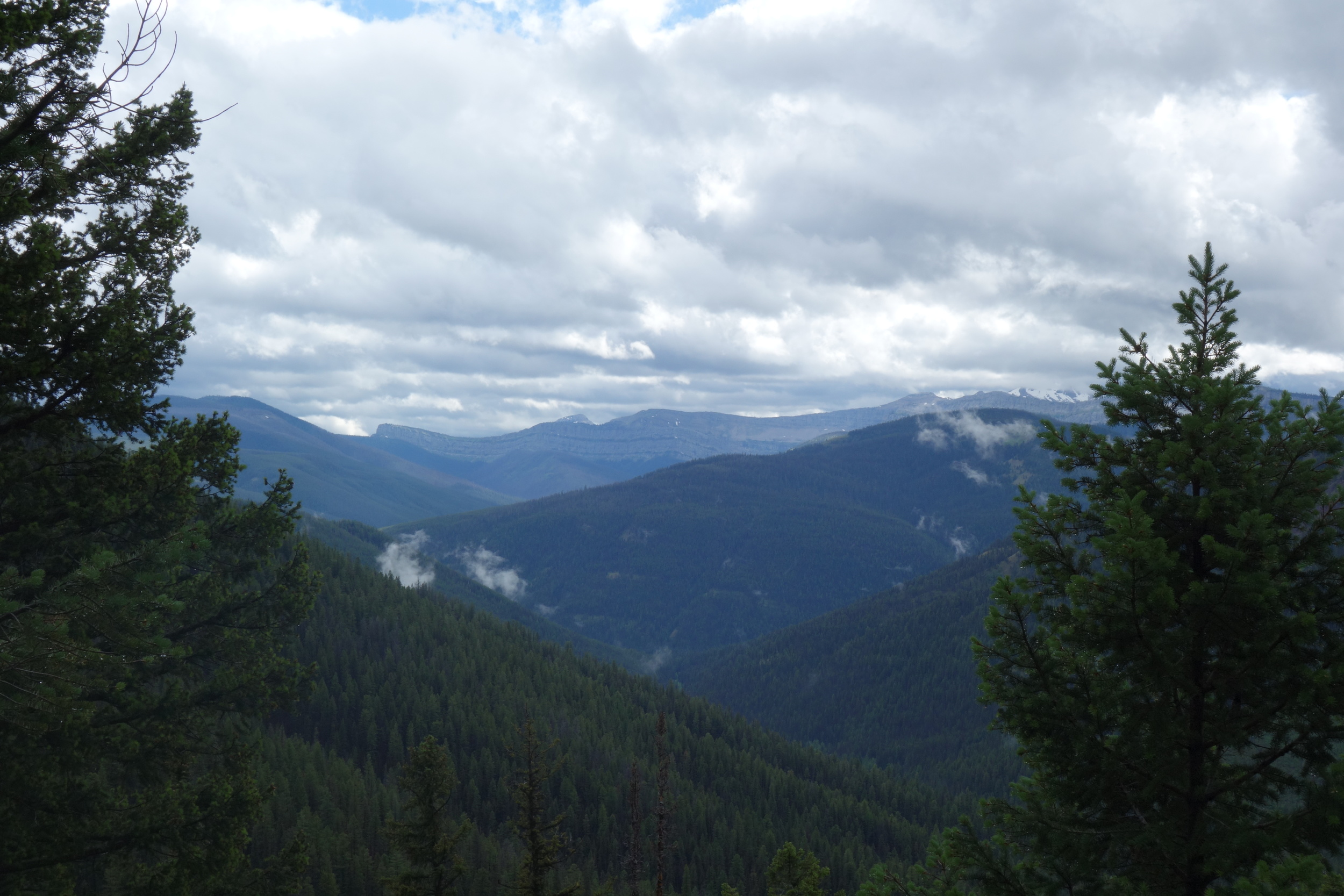
Our elevation gain for the day topped out at a pass – the name of which I can’t recall – buried inside of clouds. Aquacam and I climbed up a little side peak and stared out into the vapory vertigo abyss, unable to tell whether the negative space between peak and valley was closer to ten feet or ten-thousand. I could have stayed there all day, but alas, miles must be made. Such is the obligation of the thru.
We dropped well over a thousand feet down well-graded switchbacks to a valley floor split by a rushing creek. Halfway down, the sun appeared, and the six of us sang just about all the cliché songs about sunlight you could think of.
Where we'd be hiking the next day
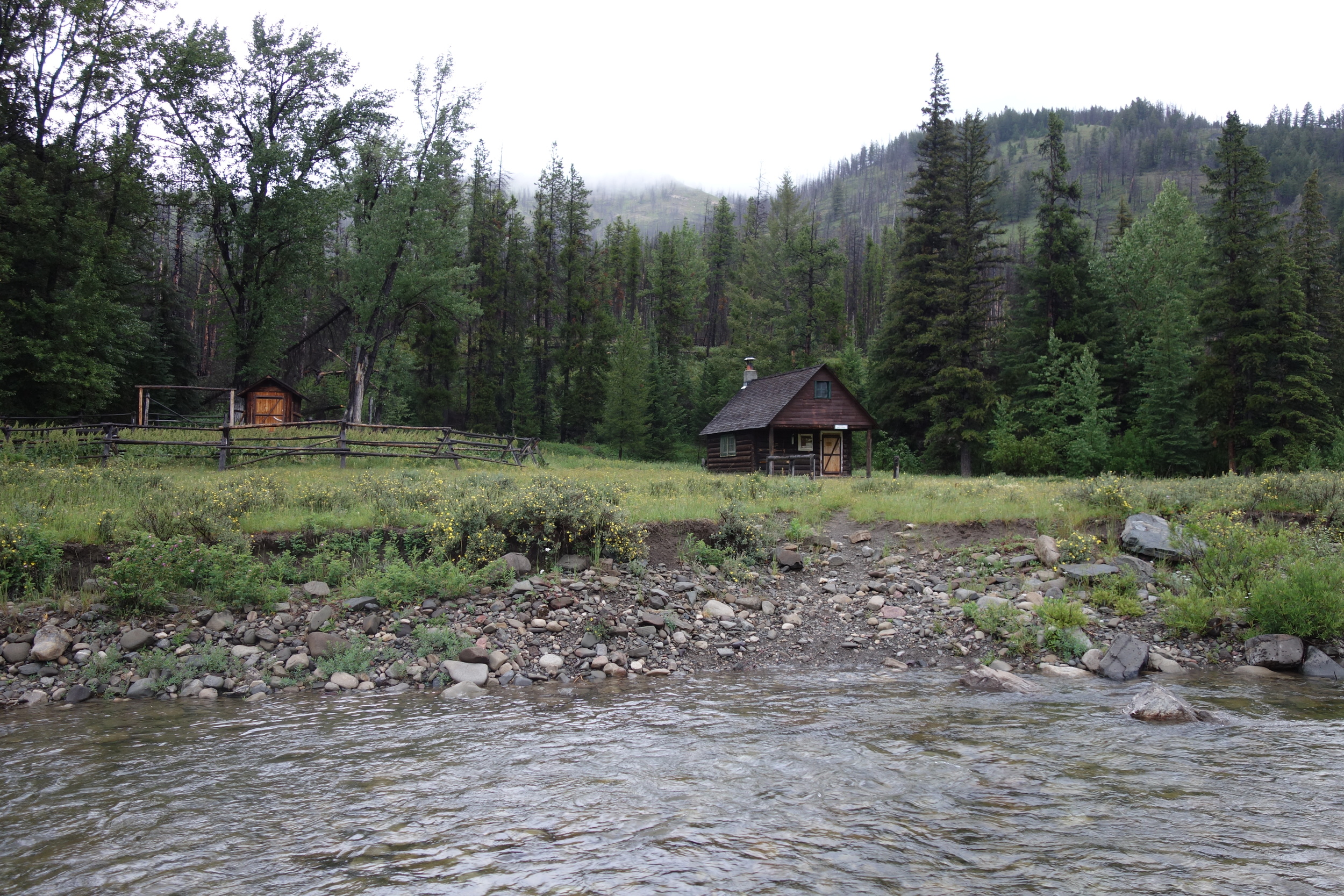
Our mileage schedule was working out perfectly that a twenty mile day landed us at another cabin, complete with porch and outhouse. We’re getting spoiled. Aquacam, Toppy and I whipped up a soup from the morels, the chives, some sage and a little instant mashed potato mix to give it weight. It was absolutely fantastic.

Backcountry gourmet!
Day 15: The first six or seven miles of the day were pretty neutral in terms of elevation gain as the trail followed the contour of the valley we had camped in. It climbed over the next three miles up to Spotted Bear Pass, where we all broke for lunch. It was a really hot day, accentuated by our having shivered through 42 degree rain the day before.
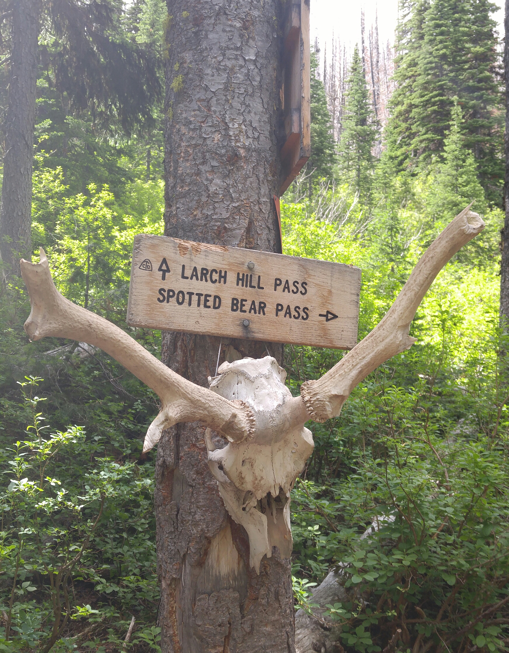
The highlight of the day was absolutely the Chinese Wall. About fifteen miles in and for the remainder of the day we followed along this escarpment that juts up about 1,000 feet and runs for twenty two miles in its entirety. There was still snow in patches throughout the talus at the base of the wall, and we amused ourselves by playing with echoes off its sweeping face. I joked that we were on the wrong side of the wall and had landed ourselves in Montanagolia; at this moment we heard horses.

Of course, we were met by a train of pack ponies, tourists and a true cowboy or two – not ancient Mongolian warriors on horseback, but I found the timing pretty funny anyhow. They were all friendly, and the cowboy in back said, “Y’all headed the wrong way; T-bones at camp tonight.” My fellow hikers groaned in hangry envy, and even I, the token vegetarian of our little ragtag squad, got caught up in fantasies of dutch oven cobblers and aluminum foil baked potatoes that surely awaited these packers at their camp, which had been set up in advance for their convenience. Top dollar packing, I tell ya.

We set up our modest camp on a hillside near Burnt Creek, just about 17 miles outside of Benchmark. None of us were really sure what to expect at Benchmark; there’s a trailhead – very popular with horse packers – and a “wilderness ranch” which was holding resupply packages for Anchor, Aquacam, Recon and me. Out of East Glacier you can either have a roughly 180 mile food carry into Lincoln, or you can split it up by stopping in at Benchmark. Easy decision as far as I’m concerned. Aside from our food boxes, which cost $25 per box to ship (no larger than 1’ by 1’ by 1’), as the folks who work at the ranch have to drive 30 miles each way to pick them up from the post office in Augusta, our intel sheets reported that you can “sometimes” get a shower at Benchmark. Anchor kept referring to this destination as “town;” in my book, it’s not town if I can’t get French fries.
Day 16: It started raining around 6:30 am. I heard Anchor clanking his tent stakes together to shake off excess dirt before I had even unzipped my sleeping bag. He took off before I even left my tent, with a “See ya when I see ya.” Anchor, like most hikers, starts jonesing for town when it’s within a day’s walk. I do too, especially early on in a thru hike, but I figured there wasn’t anything worth rushing to Benchmark for.
By the time I motivated myself out of my tent, the rain had passed. Laugh Track had shoved off as well, leaving me, Recon, Toppy and AC in the dust. We chose to have a nice relaxed day of hiking with plenty of breaks. At some point midmorning we ran into a guided trip of backpackers, all in their sixties or later. We chatted for a few minutes; I think they were as excited to see young people out enjoying the wilderness as we were to see older folks being so active in the mountains.
We passed three or four more pony/mule trains, as well as a huge horse packing camp that was presumably set up for the entire summer, crossed some burn areas; y’know, typical day of the CDT in Montana. Around five, I would guess, we made it down to a big wooden bridge (finally, a sturdy one) across the Sun River where a few different trails convened. We were looking at our maps to figure out where the ranch was, as it’s not along any of the routes drawn on our maps, when a man came up from the river and crossed the bridge.

“Got your maps out – does that mean you’re lost?” he asked. We explained that we were simply trying to keep ourselves from becoming lost, and told him where we were headed. He helped us out and asked a few questions that left us no room to dance around telling him that we were thru-hiking the CDT. Now, don’t get me wrong, it’s great to converse with people on the trail but it definitely gets tiresome answering the same questions over and over so sometimes we choose not to divulge the extent of our undertaking. He asked when we expected to finish; we told him just shy of Thanksgiving.
“Shoot, you’ve got more guts than a stuffed turkey!” he said. He saw AC’s flyrod strapped to the outside of his pack and told us he’d been fishing this river for over forty years using a simple horsehair fly that would “make any fly-tier vomit,” and that doing so kept a lot of people fed over the decades. He asked how AC had made out with the rod through Glacier and the Bob. It hadn’t gone exceedingly well. The man, who never told us his name, ended up giving AC one of his horsehair flies, wishing him better luck with the fish.
We started our roadwalk down to Benchmark while AC hung out in the river to try his luck with the new fly. After passing a turnoff that leads to where we’d pick the trail up in the morning, Toppy pointed to a cabin to the left: “There are boxes on that table,” they said. I saw that one of the boxes had fluorescent orange duct tape with black lettering scrawled across it and new instantly that it was mine. Could this be the ranch already? There was a fire going and people sitting around it.
We headed up the drive to find an old man sitting by the fire. “Who are you looking for?” he asked. I pointed to my box and explained that the “DEVANE” written on it meant it was my resupply box. He said, “Do you know Liz?” and when we looked at each other, puzzled, he shouted: “LIZ!” Only then did I realize he meant Laugh Track – Lizzy being her front country name.
LT came busting out of the cabin, all smiles, hoots and hollers as always, and asked if we were ready for a round of beers. The man, whom LT identified as Bob, told us we were wanted men around these parts, and that ‘they’ were out on a mission to find us. The three of us were real disoriented, but all I cared about was the cold beer being handed to me.
I’ll spare you the rest of the confusing rigmarole: Laugh Track and Anchor had gotten down to the road nearly four hours before we did, having only stopped to break once all day. They ran into Bob, the owner of the cabin, his friends and his son, Short, who drove them down to Benchmark Ranch. They gathered our boxes for us and, since there was literally nothing or no one else at the ranch, they headed back to Bob’s cabin, where a crew of true blue Montanans, all over 75 (except for Short), had been feeding them and keeping their cups filled. They figured we couldn't actually be four hours behind, so Anchor and Short had gone driving the road looking for us; somehow we snuck past them and vice versa. There was another hiker there, Matterhorn, who is from Switzerland and hiking the CDT in sections. He had stayed there the previous night and taken the day to rest his feet.
We spent the evening hanging out with the fellas, who only stopped drinking and chain smoking to change an oxygen tank or two. We listened to their stories of lifetimes spent in the mountains of Montana farming and ranching, what have you. The walls of the cabin were covered with taxidermy of damn near every kind of mammal you can find in Montana – only missing were a griz and a wolverine, by my estimate. Hell, they even had a ‘jackalope’.
We certainly had some conflicting opinions, to say the least, but I mostly just listened. At some point way after hiker midnight, one of the men I’d been talking with, “Tall Paul,” busted out the moonshine. “Have some white lightning!” he said. This was my cue to sneak off to sleep. The six of us crammed around the fire pit outside for the night.
