
Border Crossings, Climbs, Border Crossings, Climbs: Darby, MT to Leadore, ID
Day 40: I left Darby with Anchor, with more food than could fit in my pack and a fresh pair of shoes on my feet. We got to Chief Joseph Pass right as a thunderstorm was rolling in, naturally. After a few miles of road-walking we ended up having to take shelter under a stand of trees, as the lightning had moved within a mile and pea-sized hail had begun to pelt us. After the weather lightened up, we started the mile and a half climb up to the historic Nez Perce Camp, where we were planning to camp: the first water source south of the pass. This is the site the band of fleeing Nee-Me-Poo (Nez Perce) led by Chief Joseph rested under the assumption that they had outstripped Colonel Gibbons and his troops; anyone who is familiar with this story will recognize the tragic mistake.

At the Nez Perce camp
We were thrilled to find a fire ring and a large canvass tent that had been left assembled by a local outfitter. I was, however, not happy to discover I had lost my sunglasses at some point in the last mile and a half. I felt a bit torn – LT, Recon, AC and Smokey would be hiking up behind us at some point that evening and it was likely that they would find them, but if I waited for them to find that no one stumbled across them, I’d be backtracking in the dark or hiking I ran into the gang on their way up the climb. No one had seen my glasses. I jogged down the hill and eventually reached the spot Anchor and I had dipped into for shelter; they were right on the ground. Three off-trail miles later I was sitting around a nice fire and cooking my dinner, pretty pleased that my efforts had paid off.
Day 41: The next day had a pretty daunting climb in store for us after crossing the Montana/Idaho state line a handful of times. After dropping over a thousand feet down to a river valley, the trail takes you more than 3000 feet up over the course of six miles. Now, you may be thinking, he’s hundreds of miles in – shouldn’t his legs be in such good climbing shape that they hardly even notice the incline? Well, you’re mostly right. But climbs, when they loom before you, are a motivation killer. All of a sudden your legs are leaden and gravity doubles.

Creepy old cabin near Sheep Creek
I made decent time up the pass. A few hundred feet before the apex the trail turns to skree and it began to rain. Right around this point I ran into a NoBo.
“What’s your trail name?”
“I don’t have one,” she said, “I’m just Emma.”
“Well, certainly not just Emma! Anyway where in the UK are you from?” I asked
We chatted about England for a while and then went on our merry ways. I couldn’t help but think Idaho had been pretty inclement so far, but at least the clouds had parted enough for some stunning views. The trail follows a knife’s edge ridgeline for a while before dumping you down on the Montana side of the Divide (I think – it’s hard to remember which was which after having crossed the border hundreds of times). I stopped around seven to cook dinner with Top Shelf next to a downed old growth pine. When I strolled into camp, just before dark, Recon and LT had already started a fire. My laziness had paid off!
Day 42: The mental state of a thru-hiker at any given moment is hard to predict. In this section I began to truly feel at home in the mountains again, yet simultaneously a little beaten down by the drastic elevation changes and the limbo of being inaccessibly far both from the people I love and from all the aspects of society I don’t enjoy. The mountain air helps when struggling to focus on the present moment, but can also apparently be conducive to earworms and circular trains of thought. I like to think that thru-hiking serves as a sort of backflush of all the garbage my senses have consumed, inadvertently or through escapism, and certain things that haven’t crossed my conscious mind in years tend to get caught in the out-pipe (e.g. the song “That Don’t Impress Me Much,” by Shania Twain… seriously?).
Anyway, in comparison to the monster 3K climb the previous day, this day’s three separate climbs of one thousand feet each seemed pretty feasible. After the first climb we dropped down to one of the Slag-a-Melt Lakes – yeah, not sure where the name comes from. The sun was out so LT and I both took a dip, unsure of how many more opportunities there’d be for swimming on this hike.
The trail stayed pretty high up throughout the day, with much of the trail being approaches to or descents from passes. Someone had painted orange blazes (which looked more like exclamation points) on big boulders all along our route, presumably for snow season. It was a bit odd, but amusing. Between this spot and the next pass, a mist rolled in. I was feeling pretty ambivalent about hiking, and then came around a bend to spot Little Lake through the trees, nestled up against a strikingly sharp ridge line and the base of Homer Young’s Peak. I was instantly enamored. The trail runs across a creek that feeds the lake, and there were wildflowers of at least seven different colors covering every inch of earth that wasn’t solid rock. The trail provides.
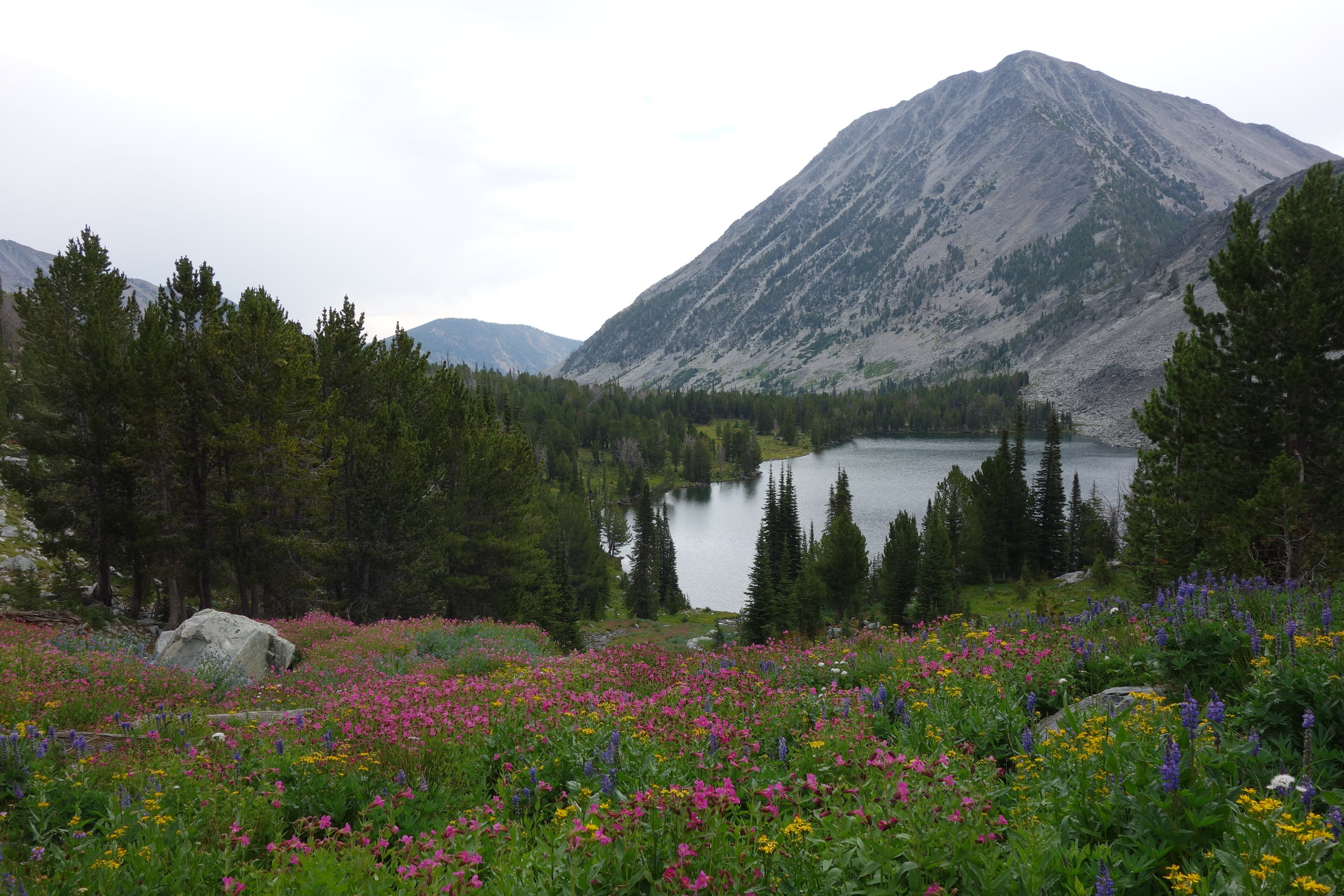
Homer Young's Peak and Little Lake, aka Heaven
The seven of us all convened at the top of a pass that had no name, at least not on our maps. Whether the group had stayed together intentionally or whether we were just all stuck on the same pace was no longer discernible, but I think everyone enjoyed one another’s company. The temperature dropped a fair amount atop this no name pass, and the wind had begun to pick up, but the views were stellar.

View from no name pass
Top Shelf and I hiked down the long descent together, chatting about vegan food joints in Portland and Seattle, as we often do. At the base of the final climb for the day, there’s a junction at which we turn right and cross a bridge over a creek. I noticed for the first time that there was a note from Ley that reads roughly: “Follow this jeep road 2.5 miles to Miner’s Lake Campground – from here you can hitch to Jackson, MT which is reportedly a really cool town with a hot springs saloon.”
Ahem. Excuse me? A hot-springs-saloon? Has there ever been a more enticing compound noun? Toppy and I picked up our pace, figuring the three ahead of us would be at the bridge. To our dismay, they had apparently already started up the hill. We sat there for a while and cooked dinner, and as AC and Smokey each rolled in, we alerted them to this intriguing bit of beta our dear cartographer had provided us. We decided against the detour, reluctantly, on the grounds that the others might worry when we never turned up, that we weren’t positive whether there was food served there, and that we ought to stay on course in order to hit Leadore, ID on time. When we got to the spot the others had chosen for camp that night, we laid into them about missing this obviously crucial bit of information.
Oh well. Perhaps we’d never know what we were missing.
Day 43: Ah, lovely. The first morning of frost covered tents. My sleep system is so dang comfortable that it’s difficult to motivate myself up off the ground each morning even when the temperature isn’t in the thirties. Add a little ice to the mixture and I’m a force to be reckoned with; well, perhaps a lack of force – an immovable object. Eventually I won (or lost) the internal argument with myself and got moving, with dreams of hot springs saloons in my head. Okay, I have to give that a little more bandwidth here for a second. I don’t know what your mental image is when you hear the phrase hot springs saloon, but I imagine Roman baths meet hunting lodge complete with swim-up bar, swinging double doors, a bartender with a handlebar mustache, sarsaparilla and ice cold beer. Just saying.
So according to the Guthook’s CDT app, twelve miles into this day would be our last reported, reliable water source for a casual 49 miles. It seemed really unlikely that this could be the case without us having heard from anyone ahead of us or any northbounders, but I watched both Recon and Laugh Track check their maps and agree that the only other sources that Ley listed were considerably off-trail and down off the Divide. Oh well, what can you do?
I stopped in a big open meadow full of sagebrush to pack-explode and dry out my icy tent. The idea of carrying water for 49 miles was weighing on me, so I decided to put headphones in and listen to music while hiking for the first time since the day after Benchmark Ranch, hundreds of miles prior. It was freaking magical. Music is basically omnipresent in frontcountry; so much so that we take it entirely for granted. I listened to the new album from one of my favorite artists and then a podcast about fracking. Time flew by. I reached the final water source, a creek with a long wooden bridge over it, around two in the afternoon and sat down to cook a meal and filter six liters of water.
Well, I ended up hanging out until four. Not good hiking practice. Anchor and Top Shelf never showed up, so we figured they must have gone one of the alternate routes by mistake – who knows, maybe there’s more water that way. I felt good on the initial climb, but I could definitely tell I was carrying about fourteen pounds of water. When I hit Goldstone Pass, where a few dirt roads converge, there was a note written in stones: “U SLOW.” This was certainly by Anchor for Smokey. I was pretty shocked that they had gotten ahead of me having gone the wrong way, but the note didn’t motivate me to move any faster – if anything, I slowed down.
The trail tracks the Divide from here, so you get beautiful panoramas all the way to Salmon, ID and Jackson, MT (yes, home of the hot springs saloon), but boy do you pay for them. It felt like one of the hardest climbs of the CDT yet. The sun began to set as I reached the pinnacle, where I ran into a NoBo who was also carrying a guitar. We were each the only hiker the other had seen carrying an instrument, and were equally stoked. He’s a hiker from Israel named Smelly Jesus. Yep. His guitar was smaller than mine, and he’d purchased it in Peru. I think both of us felt compelled to jam, but both of us were on mileage missions and sadly parted ways without even taking the sixes out of their “cases” (mine is wrapped up in the torn leg of an old pair of rain pants).

I met a few more NoBos this evening – Hakuna Matata and Bo – before reaching the spot my friends were camped. They informed me that the Guthook info about 49 waterless miles was not even remotely true, and that there would be reliable water (including pipe-fed springs) every couple miles from here to Lemhi Pass. Well, I guess chalk it up to weight training.

The spot we camped was a section full of dead trees and the only flat spot I found was beneath a few widowmakers that had artfully fallen atop one another so as to support themselves. Good thing it was nice and windy, there’s no better lullaby than the groans and creaks of massive trees that are capable of crushing you like a bug.
Day 44: I’m generally the last to leave camp in the morning when hiking with the group. I’ve probably mentioned this before. This day was no exception. I got about seven miles in without catching anyone and sat down to have a snack and strum a few tunes when Top Shelf showed up. They had gone off trail on a purple route to get water, which I had avoided due to the excess liters I’d been carrying, and accidentally gotten off trail. I admitted I, too, had been confused by all the dang two-track roads with no signage but had successfully bushwhacked without losing any time. We sat there quite a while before getting up to hike. The trees were stunted here and the sights were redundant, not to mention the clime drying up quickly, so motivation was low.
Not five minutes after taking off, we ran into a crew of four NoBos: SoJu from South Korea, Buttercup from Germany, and Maverick and Bambi who were American. There was no doubt we were in the NoBo bubble now. These four seemed ecstatic to meet us, and we traded info and stories for almost an hour, which apparently had happened with our friends just twenty minutes earlier as well. SoJu told us about the 62.1 mile day he’d done in Yellowstone, they informed us about various buffets between here and Colorado, and we gave them lots of water intel. They seemed like a fun crew to hike with, and we were sorry to be going the opposite direction.

Around noon we reached the historic Lemhi Pass, through which Lewis and Clark trudged many times, the first of which was surely a deflating experience, as it was only then that they would have seen the multiple impressive ranges still between them and the Pacific Ocean (and they couldn’t even see to the Cascades yet, let alone the Coast Range!). Here at the Pass there was a road leading down to the Sacajawea Camp and a spring called “the Most Distant Fountain,” from which the Lewis and Clark party had reportedly drunk. The water was coming straight out of the ground, and I couldn’t help but drink it without filtering.
Toppy and I decided to bushwhack back to the official route from here rather than backtrack on the road, and we did a less than perfect job navigating. I don’t think we actually saved any time, but we did see a herd of elk and get to climb the same barbed wire fence three times. From here the trail becomes an AWD road and shoots up a good eight hundred feet without shade. The payoff is that when you top out, you’re once again on the Divide, but it’s a nice wide bench on which cattle graze. We came across a note from Recon alerting us that they had a ride lined up with the innkeeper in Leadore for nine the next morning. The pass was seventeen miles away and it was eight at night. Not a chance in hell were we going to make it, so we didn’t bother rushing. The sunset was absolutely spectacular and I remembered that it was August 12th – the peak of my favorite meteor shower, the Perseids. Despite the nearly full moon’s brightness, I saw some of the most striking, brilliant meteors I’ve ever witnessed, and at a rate of about four per minute.
Toppy and I set an alarm for just shy of sun up, with the intention of booking it down to Bannock Pass and hopefully hitch a ride in a reasonable amount of time – our guidebook advises doing anything within your power to get any passing vehicle to stop, as you may not see another for hours. I stayed up as late as I could stand to watch the meteors and ended up passing out only halfway in my tent.
Day 45: An early start. I made coffee and Toppy and I took turns holding it to our chests as we began the fifteen miles down to the pass – the warmth was heavenly. Like many days going into town, I had a very one-track mind and didn’t pay much attention to my surroundings. We followed a fence for the last five miles or so, and when we reached the pass, Anchor was sitting there stretching. He had been there an hour and a half already, with only one car going the direction of Leadore. Fortunately, our luck was better, and a truck with two Montanans stopped after only twenty minutes and happily dropped us down in the “city” of Leadore, population 105. Oh, they also told us that the hot springs saloon in Jackson is fan-freaking-tastic. Typical.